The Arlington Exit Plot
 Students are introduced to the practice of "Ekphrasis" to practice "reading" an image/photograph.
The Arlington Exit Plot
💡 Concept
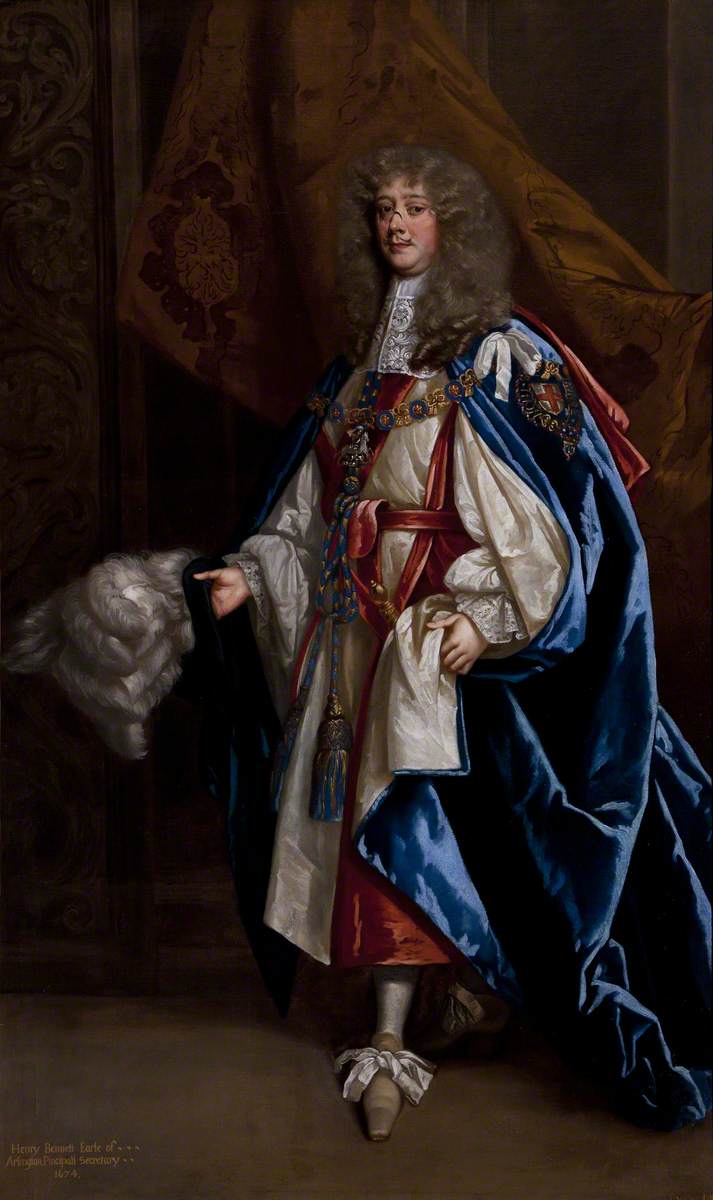
Henry Bennet (1618–1685), 1st Earl of Arlington, in Garter Robes
Peter Lely (1618–1680) (and studio)
National Trust, Kedleston Hall and Eastern Museum
Henry Bennet, 1st Earl of Arlington (1618-1685), bore a hideous scar across the bridge of his nose. The indelible signature of a battle wound received in the English Civil War, this put him a leg up on fellow swashbuckling cavaliers, who more typically lost their noses to syphilis. Arlington was close to Charles II through thick and thin, and remained with him in exile in continental Europe during the Interregnum. It is rumored that he, like Charles, also sired a child with Lucy Walter (mother of James, Duke of Monmouth), who succumbed to the venereal disease at 28. For those of you on the lookout for good stories to tell, Arlington is chock-full. His rise to prominence seems to be founded on his ability to procure people and things, and to put his name on the map.
A few bullets toward his resumé:
- Poet & scholar (Westminster School/Oxford, fluent in Dutch, French, and Latin)
- Secretary to James, Duke of York (1654)
- Knight (1657)
- Member of Parliament (1661-1665)
- Keeper of the Privy Purse (1661-1662)
- Secretary of State (1662)
- Postmaster General (1667-1685)
- Earl (1672)
- Order of the Garter (1672)
- General manager of the King's many extra-marital affairs
Plotting The Road from LONDON to DOVER
Arlington's real talent, that which earned him the ignominious sobriquet eminence grise (literally "grey eminence," these are shadowy types that hang around rulers and whisper dark ideas), was for being sneaky. No deed emanated more darkly than The Treaty of Dover, a wholesale betrayal of the Protestant / Anglican / Parliamentary order: Charles's secret agreement with French King Louis XIV to turn his coat Catholic in exchange for a lump sum £200,000, and a 6,000 men amphibian assault squadron. Charles signed it, but Arlington, the alpha jackal of a pack called C.A.B.A.L.,* did most of the talking. Planning for this real "Popish Plot" began years before, through encrypted correspondence (now destroyed) between Charles and his sister, Henrietta, wife of Louis' brother Philippe, duc d'Orléans, then living in France. Arlington was one of two ministers privy to all aspects of the conspiracy and he helped plot it out, using maps.
It was the Earl of Arlington who, upon John Ogilby's return from Ireland in 1665, helped set him upon a new career path as geographer (after masque dancer, master of revels, translator of fables and epic poetry), with copyright protection from the highest authority against the Stationers Company in the plotting of travel routes and destinations in and around London for print publication. "The Road from LONDON to DOUER in co[unty]: Cant[erbur]y" was not published in the atlas Britannia until 1675, but a comparable one-off print was likely ready for use by Charles's retinue in their secret seaside rendezvous in 1670. Look closely below at the local map of Dover and see what you can see, imagining that you are Henry Bennet, 1st Earl of Arlington, scouting out the spot for several dozen royals' "trip to the beach" as cover for a turncoat signing ceremony. Then zoom out to see the big picture. A plot is a plan. And a plan is, first and foremost, a matter of logistics.
*"Cabal," now a general term for high-ranking, conspiratorially-minded government official insiders, is derived from an acronym of initials: Sir Thomas Clifford, Lord Arlington, the Duke of Buckingham, Lord Ashley and Lord Lauderdale, who coalesced around Charles II in 1668.
📍 Location
According to the Washington Post, almost half the states in the U.S. can pin something as Arlington. The largest is a city in Texas, home of the Rangers baseball team (turncoat Washington Senators), and the closest to the seat of power is a county in Virginia, home to the highest concentration of college grads in the U.S. Before the so-called "Retrocession" of 1846, the District of Columbia was a neat, quarter-turned square of 10X10 miles. But they gave "Alexandria County" back to Virginia to appease slaveholders, and today it's called Arlington County, in honor of Robert E. Lee's former family home (smack in the middle of Arlington Cemetery), named by George Washington Park Custis (Martha Washington's grandson). The connection to Henry Bennett, 1st Earl of Arlington is indirect: Arlington House was named after Arlington's actual plantation in coastal Virginia, which he acquired in 1670, perhaps a payoff for managing the Treaty of Dover. Arlington Plantation eventually became the Custis family estate. Arlington never stepped foot on it.
Take a minute with the map below to appreciate the vision that once was for a well-balanced capital city, the seat of power in a new, democratic realm carved out as a "district" from two competing states (Maryland and Virginia) by French Enlightenment urban planner Pierre l'Enfant. Then zoom in and follow the line from points 2,3,4,5, and 6 (now the White House) back across the Potomac to the other side. That line today is the George Washington Memorial Bridge, a spiritual route, if anything, for U.S. presidents to commune with the Civil War dead and their followers in Arlington Cemetery.
So how did we get so many Arlingtons?
Let's start with Bennet's own home. Here's a spectacular view from across the river Thames, from a print found at the British Museum (It's not the one in the front: look at the little house in the distance up top, where it says "ARLINGTON HOUSE" in the margin to the left.)
Below, again, is Morgan's 1682 map "London, &c." Zoom in and take another look at Arlington House. That's on the top map, far left, just below center. From there you can trace a bee line to Whitehall. Henry Bennet, 1st Earl of Arlington had many routes, direct and indirect, to Charles's ear, including a special back stair between his offices and Charles' privy chambers. He could swim, if he had to, in the canal, or ride an ostrich (just above the E in the lower "St. James Park" lettering, this big bird is identified by Ralph Hyde as one of 30 presented to Charles in tribute from the Moroccan ambassador, Mohammad Ohadu in early 1682). For perspective, that relatively modest, but well-situated and appointed house, is now Buckingham Palace.
Where are we now?
To bring this closer to home, Los Angeles has a number of Arlingtons, including Arlington Heights, and the road it was named after, Arlington Avenue. There isn't really a direct historical connection anymore, an ocean, continent and two centuries removed from the old guy himself. As a distant ripple of its original splash, "Arlington" was chosen along with many other Anglo sounding places in a street-naming flurry during the 1870s for no other reason than to imprint the expanding streetscape of urban Los Angeles as English-speaking, and not Spanish. Now it is probably most readily recognized by hard-driving Angelenos as an exit off the 10 freeway. Our exit.
You can zoom along Arlington Avenue and Adams Boulevard in this second map from 1924, from UCLA's own Bruman Map Collection (thanks to UCLA Library Digital Collections), made just before ground was broken for the William Andrews Clark Library. The imagined library is one block down, one to the left from the wishbone loop on the left side. Ostriches aren't drawn on this map, but they could have been found at the time at the Cawston Ostrich Farm along the Arroyo Seco. That's in the upper right corner.
- Major Traffic Street Plan Los Angeles California (1924). UCLA Library Digital Collections. Henry J. Bruman Map Collection
The road from UCLA to the William Andrews Clark Memorial Library is long, circuitous, and poorly traveled. Funding for Uber or Lyft ride-share alleviates the financial burden upon students who seek access to the Clark's hidden treasures, but can do precious little about the notorious Los Angeles traffic and road rage on the "Interstates" 405 and 10 (traces of the Eisenhower administration's Cold War conspiracy with Detroit auto magnates to subjugate left-leaning Los Angeles).
The Founding Fellows
In Spring of 2014, a tight circle of capstone seminarians called Bygwwck,* led by Dr. Stephanie Koscak, post-doctoral “Fellow” with the William Andrews Clark Memorial Library, began meeting in its remote halls and reading rooms, where they hatched a plan for a public display of items from the Clark’s collections, based upon “violent party politics,” “political revolution,” not to mention “lies, controversies, and fallacious news” and playing cards. “The ink hath poyson in it,” they wrote.

For less credulous readers from our own age, this group has left documentary evidence, hidden in plain view to the public on an antiquated medium, or blog ("The Clog"). Below is a direct transcription, in full, of their manifesto, alongside a trompe-l'œil (trick of the eye) painting they used to confuse and deceive their viewers.
 The Tears of the Press: Print & Authority in 17th-Century England
“What age ever brought forth more, or bought more printed waste paper?”, asked the anonymous author of the 1681 tract The Tears of the Press, with Reflections on the Present State of England. The temporary and then permanent lapse of prepublication print licensing, the emergence of violent party politics, and political revolution redefined the relationship between print and political authority for the English in the later seventeenth century. Packed with supposed lies, controversies, and fallacious news, readers consumed print like never before: “The ink hath poyson in it,” lamented our above author, yet “pamphlets these late times hath swarmed.”
This obsession with paper and the press in seventeenth-century England reflects new anxieties, tensions, and possibilities surrounding representation in an age of increasingly mass textual and graphic print. By the turn of the eighteenth century, the press had expanded beyond all previous bounds with the explosion of ephemeral print, particularly newspapers, pamphlets, engravings, satires, and broadsides. This exhibition, curated by students in Dr. Stephanie Koscak’s undergraduate capstone seminar in the Department of History at UCLA, “Media and Politics in Early Modern England,” aims to capture the vitality and novelty of print in this period. Collectively, these rare texts and images demonstrate the ways in which authority was constructed through print while addressing contemporary anxieties about veracity and misrepresentation. Topics include: the development of newspapers, the construction of royal authority in graphic images and printed pamphlets, the invention of mass partisan propaganda, the channels of printed communication undergirding the mid-century witch crisis, and emerging genres of engraved visual satire, such as political playing cards. Like the printer George Bickham’s large, hand-colored trompe l’oeil engraving The Whig’s Medley (1711), included in the exhibit, print playfully reflected back on its own complexities. Authors and artists asked contemporaries to read dialogically, to compare multiple representations, and to cultivate sharp interpretive skills necessary for England’s new media landscape
The deeper intent of this ephemeral sequence of events was to usher in a new era of hands-on undergraduate research with primary source materials, building a bridge, imaginary, spiritual, or otherwise, across the chasm of freeways that divide UCLA from the Clark. Although momentous in its own time, the seismic impact of this movement today is hardly felt. That does not mean, however, that the trace is lost altogether.
Viva la Revolution!
Although most of the original participants in the Exhibit of 2014 have long since graduated and gotten almost old (some near 30!), a few tangential figures have remained behind to keep the flame lit. The Revolution went underground, in other words, where it has lain dormant. In more recent days, intrepid researchers have uncovered a cache of evidence that connects this failed plot to our own activities, by tracing personal connections and networked career trajectories. An intercepted email, for example, reveals incontrovertibly, despite denials and obfuscation, that someone in our very midst hatched a plan 8 years ago that we have been carrying out, until now, unwittingly.
The Arlington Exit Plot
Times have changed, and with them, technology. We have regrouped as a movement, and in the spirit of those who have gone before us, we seek to plot a path for future inquiry between UCLA and the Clark Memorial Library. Your final assignment, should you choose to accept it, is to enlist as students in the curatorial cabal known as the Public History Initiative (a filial of the History Department), in cahoots with the DCP (Digital Curriculum Program), a sleeper cell of the DLP (Digital Library Program).
The plan is to bypass the Arlington Exit, as well as the 405, 10, and all Overland routes altogether, and secure direct access to the Clark's hidden information about Restoration England (as well as the rest of the 17th and 18th century books and ephemera) through securely buried high-speed fibre optic cable and encrypted network connectivity. That is, in other words: to digitize select, curated items from the Clark Library physical holdings and create from them a primary source teaching collection for use in UCLA courses in history, English, spycraft, and library sciences. Students and faculty will, of course, continue to make the pilgrimage to this bibliographic Mecca, the mythical land of Serendip, as an act of faith and scholarly verification. But interoperable open access to the documents for planning, decoding, or other purposes before and after on-site inspection will help their plots thicken.
*Not a Welsh assassin squad, "Bygwwck" is an acronym for the participants of HIST 191 "Media and Politics in Early Modern England" (2014): Nicholas Barlow, Sean Patrick Yancey, Ricardo Aaron Garcia, Amber Ward, Maksim Wynn, Hillary Rose Cleary, Brian Jordi Thomas Knight)
🧱 Materials
- For a table of curated source materials relevant to the course topic, return to: Unit 2 Lab Activity: Commonplacing
- For help with IIIF content, go to: Unit 3 Content: IIIF
🛠️ Tools
ArcGIS StoryMaps is an easy-to-use and flexible platform for authoring multimedia scholarly essays. It can also be used to embed mini-projects created in other tools. Below is a short, annotated list of tools you might consider using as part of your project:
A IIIF compatible viewer for framing, sharing, and embedding IIIF content, using IIIF manifest URLs
A visual tool for cropping a detail from a IIIF image and generating a URL
- Liz Fischer's IIIF Manifest Explorer
Developed by a starving digital humanities graduate student, this thoughtful tool fills an important gap in the IIIF universe: a way to get image URLs from a IIIF manifest by looking at their thumbnails
- Storiiies (by cogapp)
A zoom and pan "slide show" that lets you present a high resolution image (IIIF link or .jpg file upload) detail views with sequential captions
- Exhibit. (by Mnemosyne)
Similar to Storiiies, Exhibit. is a tool for zoom-based presentations with captions. It is IIIF only, but has more features than Storiiies, and it can present more than one image.
- HTML Embed
<iframe src="https://blah blah blah" width="100%" height="800" allowfullscreen="allowfullscreen"></iframe>
🪛 Project Stages
- Submit Primary Sources assessment (9/29)
- Submit "Commonplacing" topics (10/26)
- Submit Project Prospectus (11/3)
- Submit "Lorem ipsum" project mockup on ArcGIS StoryMaps (11/8)
- Submit draft project on StoryMaps
- Submit final project on StoryMaps, by means of a fully functional link to your published project. Please feel free to add a reflective statement as part of your submission.
📩 Submission
- Click on Submit Assignment button above to share links to your work.
On mobile devices, navigate to the Submissions tab.
Rubric
On mobile devices, navigate to the Grade tab to see rubric.